RCAHMS National Archaeological Survey: Eastern Dumfriesshire


Date March 1990 - December 1996
Event ID 1118085
Category Project
Type Project
Permalink http://canmore.org.uk/event/1118085
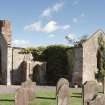
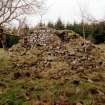
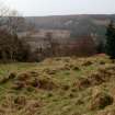
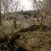
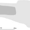
Eastern Dumfriesshire occupies an important location at a crossroad in the communication network today, and the medieval and Roman evidence shows that this has long been the case. Scenically there is great variety, from the stark hills of the Devil's Beef Tub to the rolling green Solway plain. The present survey of the archaeology of Eastern Dumfriesshire outlines the ways that the landscape has been used through time and the effect that this has had on the preservation of archaeological evidence. The understanding of the formation of the countryside as it exists today lies behind any attempt to describe it as it may have been in the past; this helps to elucidate the broad changes that took place in the past and thus acts as the natural backdrop to the patterns of types of monument that form the archaeological expression of these changes. The format of this volume takes further the development in style begun with the volume on North-east Perth and continued in South-east Perth; in Eastern Dumfriesshire the environmental background is integrated in ways that were not formerly possible. Several programmes of research in and near Eastern Dumfriesshire had been undertaken in the past, and Dr Richard Tipping, Department of Environmental Sciences, University of Stirling, was invited to contribute an introductory chapter that would draw these threads together in an authoritative way and provide this essential background to patterns of ancient and modern land use. In order to make fullest use of this approach three case-studies of contrasting parts of Eastern Dumfriesshire have been undertaken, thereby setting the layers of archaeological evidence within a particular local landscape type; the Solway plain, the Kinnel Water and Upper Eskdale have been discussed in this way. Individual categories of monument are examined within the broader context of site type and period, with particular attention in the medieval period being paid to the possibilities of the identification of estates. The emphasis is on distillation not description. Field survey has as its aim the enhancement of the National Monuments Record of Scotland and the detailed site descriptions which form the foundation of the present study are lodged there. This national database is now designated as 'the Inventory of Ancient and Historical Monuments of Scotland', the compilation, maintenance and curation of which is entrusted to the Commissioners by Royal Warrant. The national nature of this database has been indicated on the end map in order to emphasise the change of focus from publication, with all archaeological field projects undertaken since 1987, whether destined for publication or not. The detailed records of all projects are lodged in the National Monuments Record of Scotland, along with the records from many other sources, and are available for public consultation (see Editorial Notes).
The majority of the fieldwork was conducted between spring 1990 and autumn 1994, although selective site-visits have been carried out until the end of 1996; the gazetteer covers all sites and monuments recorded in the area prior to April 1997.
Fieldwork for the survey has been carried out by John Borland, Georgina Brown, Marilyn M Brown, Peter Corser, Iain Fraser, Angela R Gannon, Alan J Leith, Stratford P Halliday, Kevin H J Macleod, Gordon S Maxwell, Ian G Parker, Sam Scott, Robert Shaw, John R Sherriff, Ian M Smith, Jack B Stevenson, Heather L Stoddart and Adam Welfare. Photographic services have been provided by Robert M Adam, Tahra Duncan, John D Keggie, Angus G Lamb, James M Mackie, Anee P Martin, Derek M Smart, S A Thomson, and Steve Wallace. The text has been written by P Corser, D Craig, I Fraser, A R Gannon, S P Halliday, J R Sherriff, and R Tipping and edited by S P Halliday and J N Graham Ritchie, with the assistance of A Welfare. The drawings and other illustrative work have been undertaken by J Borland, G Brown, A J Leith, K H J Macleod, I G Parker, R Shaw, and H L Stoddart. The layout of the volume has been prepared by John N Stevenson with the assistance of K E George and L Marr. The results of the survey have been incorporated into the National Monuments Record of Scotland by Robert J Mowat.
The Royal Commission wishes to acknowledge the assistance given by all the owners of the archaeological monuments, who have allowed access for study and survey, and also the cooperation of the staffs of the Crown Estates, Dumfries Museum, Dumfries and Galloway Planning Department, the Forestry Commission, Glasgow Art Gallery and Museum, Historic Scotland, the National Library of Scotland, the National Museums of Scotland, the National Trust for Scotland and the Scottish Record Office. Particular thanks are due to the Duke of Buccleuch, for allowing access to estate maps and documents held in the Scottish Record Office, D Craig, for his contribution of the sections dealing with the Early Historic archaeology and sculpture, Chris Lowe, for providing photographs of his excavations at Hoddom in advance of publication, A R MacDonald, for the information about Canonbie Ironworks, Roger J Mercer for making available unpublished information from excavation and survey and for editorial advice, R Tipping, for the sections dealing with the environmental history of the area, and Humphrey G Welfare for commenting on the final text of the volume. Dr J Murray kindly made material available from ongoing research. The advice of Professors Rosemary J Cramp, John M Coles and Thomas C Smout in the preparation of the text is gratefully acknowledged.


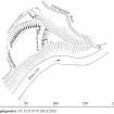
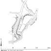
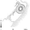
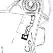
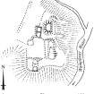
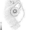
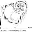
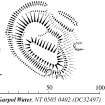
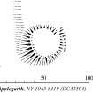
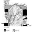
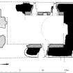
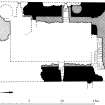
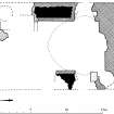
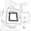
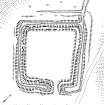
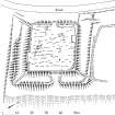
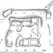
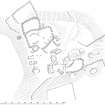
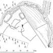
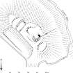
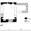
![Publication drawing; Plan of Liddle Castle earthworks, redrawn from Inventory illustration [1912] for publication with comparative plans of mottes and medieval earthwork monuments.](http://i.rcahms.gov.uk/canmore/l/SC00382013.jpg)


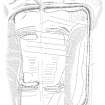
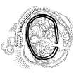
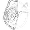
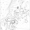
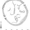
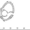
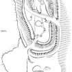
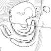
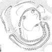
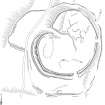
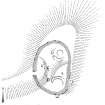
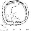
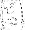
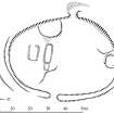
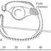
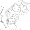
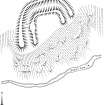
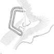
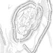
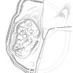
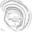
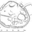
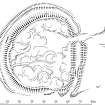
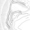
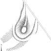
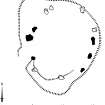
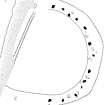
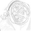
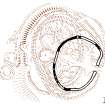
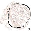
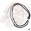
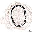
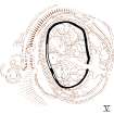
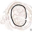

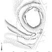
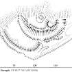
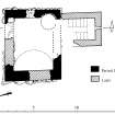
![Publication drawing; Plan of Liddle Castle earthworks, redrawn from Inventory illustration [1912] for publication with comparative plans of mottes and medieval earthwork monuments.](http://i.rcahms.gov.uk/canmore/s/SC00382013.jpg)