
Boreray


Head Dyke (Post Medieval), Township (Period Unassigned)
Site Name Boreray
Classification Head Dyke (Post Medieval), Township (Period Unassigned)
Canmore ID 123346
Site Number NF88SE 15.01
NGR NF 8517 8130
NGR Description centred on NF 8517 8310
Datum OSGB36 - NGR
Permalink http://canmore.org.uk/site/123346


- Council Western Isles
- Parish North Uist
- Former Region Western Isles Islands Area
- Former District Western Isles
- Former County Inverness-shire
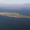
NF88SE 15.01 centred on 8517 8310
A township comprising fifty-three roofed, two partially roofed, seven unroofed buildings, several enclosures and a head-dyke is depicted on the 1st edition of the OS 6-inch map (Inverness-shire, Hebrides, Harris, North Uist etc 1880, sheet xxvi). Three roofed, fifty-two unroofed buildings, several enclosures and a head-dyke are shown on the current edition of the OS 1:10000 map (19 71).
Information from RCAHMS (SAH) 21 March 1997
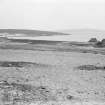
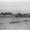
An aerial photograph (CEU 1980) centred at NF 8540 8110) depicts part of the township on Boreray, showing one unroofed building and the remains of eleven buildings, around the bay of Traigh na Luibe and NE of Loch Mor.
Information from RCAHMS (ALD) 3 June 2004

