
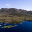
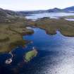
North Uist, Loch Hunder


Broch (Iron Age)(Possible), Causeway(S) (Prehistoric), Dun (Prehistoric)
Site Name North Uist, Loch Hunder
Classification Broch (Iron Age)(Possible), Causeway(S) (Prehistoric), Dun (Prehistoric)
Canmore ID 10416
Site Number NF96NW 5
NGR NF 9046 6525
Datum OSGB36 - NGR
Permalink http://canmore.org.uk/site/10416


- Council Western Isles
- Parish North Uist
- Former Region Western Isles Islands Area
- Former District Western Isles
- Former County Inverness-shire
NF96NW 5 9046 6525.
(NF 9046 6525) Dun (NR)
OS 6"map, Inverness-shire, 2nd ed., (1904)
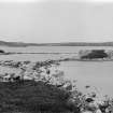
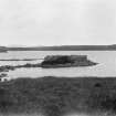
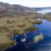
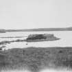
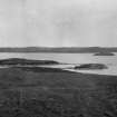
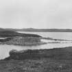
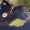
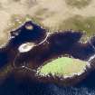
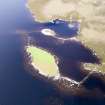
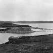
This dun is representative of many examples of similar duns occuring in the Outer Isles, the date of which is uncertain. It occupies an islet near the E shore of the loch to which it is connected by a causeway. Another causeway connects it with a second islet and a third runs from this to the far shore. The dun is a flattened oval on plan measuring about 40 x 34ft over a wall which varies from 5-10ft thick and which includes at least one chamber, probably more (R W Feachem 1963). Classified as an 'island-broch' (E Beveridge 1911).
E Beveridge 1911; RCAHMS 1928; R W Feachem 1963.
As described above. Opposite the end of the causeway at 9048 6515, there is a small D-shaped enclosure measuring 6.5 x 5.5m constructed of large stones. It has been scooped out of the hillside and has an entrance facing the causeway.
Visited by OS (N K B) 11 June 1965.
Field Visit (3 August 1915)
Dun, Loch Hunder.
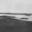
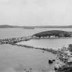
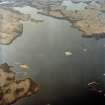
On an island in a small bay on the eastern shore of Loch Hunder, near its south-eastern corner, is a dun of uncommon type, and specially interesting from the network of causeways connected with it. The dun occupies nearly the whole surface of an islet, some 35 yards from the northern and eastern shores of the bay, while about 50 yards to the south-west is a larger island, partially defended on the landward side, which has formed an annexe to the chief structure. Access to the dun is obtained by a causeway, which, making a considerable bend towards the south, extends from a slight promontory on the east shore of the loch to the south-eastern part of the building. When visited in an exceptionally dry summer, the causeway stood about 2 feet above the water; it measures 40 yards in length, and some 3 feet in breadth on the top at the best preserved part, though in other places it is nearly 7 feet wide. In two places there are gaps in the causeway from 2 to 3 feet wide.
A second causeway connects the dun with the annexe on the island to the south-west. Commencing on the western side of the dun it extends in a straight line about 20 yards into the loch, then completes a western semicircular curve in a length of about 15 yards, after which it abruptly turns and goes directly south to the northern end of the annexe, which is reached about 18 yards further on. This causeway is generally about 1 foot lower than the first causeway.
There is yet another causeway joining the southern end of the annexe with the eastern shore of the loch. It stands about 1 foot above the water, and makes a sharp change of direction in its course. For some 25 yards it runs out from the shore in a westerly direction, its width being about 4 feet 6 inches on the summit, then it makes a sharp angle to the north-west joining the island annexe after a length of some 22 yards; the latter portion is about 8 feet in width in places. (Fig. 115.)
The dun is in a better state of preservation than the majority of these structures in the islands, the wall standing to an average height of 5 and 6 feet. Though roughly oval on plan, measuring some 40 feet 8 inches over the top of the walls from north-west to south-west, and some 34 feet 7 inches from north-west to southeast, the wall does not follow a regular curve, but for short distances is almost straight, especially on the north, and opposite the causeway bulges out slightly. It measures 4 feet 10 inches in thickness at its present summit on the south-west, and 5 feet 2 inches on the north. The entrance is quite obliterated, but seems to have been placed a few feet north of the island end of the causeway. Immediately to the southwest of this place the wall has a thickness of some 10 feet, apparently to make room for an oval chamber in the thickness of the wall, the dimensions of which cannot be ascertained. On the northern arc there are doubtful indications of an oval chamber or gallery, about 2 feet wide, within the wall in the shape of a coved western end. The interior of the building is full of stone to an apparent depth of about 5 feet.
The island annexe, which rises to a maximum height of some 12 feet above the water, measuresabout 168 feet from north-north-east to south-south-west and some 70 feet across. From the causeway at its northern end to within 48 feet of the causeway on the south its landward or eastern flank has been protected by a line of slabs, about 2 feet in height, set on edge a few feet from the edge of the island. At the southern end of this flank the island is bounded by a sloping rock which evidently has been considered a sufficient defence in itself. There are also the remains of a stone wall built across the inner end of the causeway. In the face of the bank of the loch opposite the causeway, some 28 feet from and 10 feet higher than the shore, is a rectangular, excavated and stone-walled enclosure, measuring some 17 feet long and 15 feet 6 inches broad, the wall in the south-east corner showing a height on the inner face of about 3 feet.
RCAHMS 1928, visited 3 August 1915.
OS map: North Uist xl.
Publication Account (2007)
NF96 1 LOCH HUNDER
NF/9046 6525
Probable broch – classified as a dun by the Commission [2] – in North Uist is situated on an islet in a small bay in Loch Hunder, which is very close to the north shore of the sea loch Eport. The building occupies almost the whole surface of the islet which is about 23m (35 yds) from the northern and eastern shores of the bay. It is connected to the shore by a causeway and another causeway connects it with a second islet and a third runs from this to the far shore. The dun is a flattened oval on plan measuring about 12.2m by 10.4m (40 by 34 ft) over a wall which varies from 1.5m – 3.0m (5 – 10 ft) thick and which includes at least one chamber, probably more
Sources: 1. NMRS site no. NF 96 NW 5: 2. Beveridge 1911, 161-2: 3. RCAHMS 1928, 53, no. 173 and fig. 115: 4. Feachem 1963, 183.
E W MacKie 2007

