
North Uist, Vallay, Leac Nan Cailleachan Dubha


Chambered Cairn (Neolithic)(Possible), Standing Stone(S) (Prehistoric)
Site Name North Uist, Vallay, Leac Nan Cailleachan Dubha
Classification Chambered Cairn (Neolithic)(Possible), Standing Stone(S) (Prehistoric)
Canmore ID 10037
Site Number NF77NE 19
NGR NF 7908 7650
Datum OSGB36 - NGR
Permalink http://canmore.org.uk/site/10037


- Council Western Isles
- Parish North Uist
- Former Region Western Isles Islands Area
- Former District Western Isles
- Former County Inverness-shire
NF77NE 19 7908 7650.
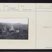
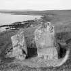
(Area : NF 789 765) Immediately above the shore, and a little to the east of St Mary's Chapel (NF77NE 6) are two large standing stones calles Leac nan Cailleachan Dubha. Situated at the east end of a slight mound, they undoubtedly represent a prehistoric burial. A much-worn hammerstone was found here.
E Beveridge 1911.
These two stones, 0.5m apart, were located at NF 7908 7650. The northernmost stone measures 1.6m high by 1.1m wide by 0.2m thick: the other measures 1.4m high by 0.9m wide and 0.2m thick. They probably represent the remains of a burial-chamber. Their name could not be confirmed.
Visited by OS (W D J) 22 June 1965.
Field Visit (28 July 1914)
Standing Stones, Leac nan Cailleachan Dubha, Vallay.
A short distance above the south-eastern shore of Vallay and to the east of Teampull Mhuir (NF77NE 6) are two standing stones, Leac nan Cailleachan Dubha, 19 inches apart, placed almost in a line running north and south, the broader aspects of which face the east. The most northerly slab measures 5 feet 8 inches above ground, 4 feet in breadth, and 9 inches in thickness, and its neighbour is 4 feet 5 inches in height, 3 feet 1 inch in width, and 9 inches in thickness.
Local tradition says these stones were erected on the spot where two women, who had been caught in the act of milking cows which did not belong to them, were put to death and buried. The name means “flat stone of the black women” or nuns.
RCAHMS 1928, visited 28 July 1914.
OS map: North Uist xxx (unnoted).

